Tropical Storm Gordon misses area, turns northward at last minute
Published 9:44 am Wednesday, September 5, 2018
From The Daily Leader
BROOKHAVEN — The weather is fine and sunny in Virginia Beach, Virginia, today.
A nice, little 5 mph breeze blowing out of the northeast will fan across bright, blue skies, free from rain, with temperatures in the mid-80s. The Old Dominion is enjoying fair weather because of a high-pressure system sitting in the middle of the eastern seaboard, pushing turbulence away.
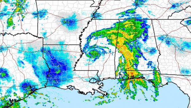
That system is also why Tropical Storm Gordon yanked off its track late in the night of Tuesday, taking a northward turn up through eastern Mississippi and missing Lincoln County entirely.
Tropical Storm Gordon found the alley late Tuesday night when it made landfall near the Alabama-Mississippi state line, farther east of a predicted track that originally had the storm’s eye making a dead-center approach over Brookhaven.
Instead of following the predicted course across Southwest Mississippi, Gordon began churning north-northeast, taking its hard rains and stiff winds up through the Pine Belt region and, as of 8:30 a.m. this morning, right over Jackson.
Revised forecasts call for Southwest Mississippi to receive light rain throughout today and into the afternoon as Gordon’s belly slides by 50 miles north, but any threat of serious weather here ended during the night. Winds may pick up to 10-15 mph, Galey said.
But like everything else with Gordon, even that’s not certain.
“Y’all are far enough south that any impacts down there should be relatively minimal compared to other parts of the state,” Winesett said. “Confidence is lower down there for another band to develop, but it’s not entirely out of the question to see localized heavy rainfall later.”
Winesett said Gordon — now weakened to a tropical depression with sustained winds of 35 mph — will bring heavy rains and flash flooding to the Delta as it moves northwest at 14 mph, and it’s main eastern arm is currently spinning off over the I-20 corridor, bringing storms on a line stretching from the Golden Triangle down to Pensacola, Florida. The band will drag into eastern Mississippi as Gordon heads west, he said.
NWS forecasts call for the storm to weaken to a post-tropical state by 1 a.m. Friday, at which point the center will be over Little Rock, Arkansas, and it will eventually blow out over Missouri, with the rainy remnants carried east to the Midwest by early Monday morning.
Tropical Storm Gordon was near hurricane strength when it made landfall Tuesday night, bringing flash flooding and wind damage to coastal areas, killing a child in Pensacola after a tree fell on a mobile home.
More News


SportsPlus
How to Watch the NBA Today, December 13
In one of the eight compelling games on the NBA card today, the Los Angeles Clippers and Denver…
NBA Spread and Total Picks for Today, December 13
The NBA lineup today is not one to miss. The contests include the San Antonio Spurs squaring off…
Best Bets for NCAA Basketball Picks Against the Spread for Friday, December 13
Friday’s college basketball slate has plenty of excitement, including a matchup between the Georgia Southern Eagles and the…
Will Gustav Nyquist Score a Goal Against the Stars on December 12?
When the Nashville Predators play the Dallas Stars on Thursday at 8:00 PM ET, will Gustav Nyquist score…
Saints vs. Commanders: Odds, Moneyline, and Spread – Week 15
The Washington Commanders (8-5) are listed as 7.5-point favorites on Sunday, December 15, 2024 against the New Orleans…
-
Polls
 Loading ...
-
-
Special Sections
