Hurricane warnings issued for New Orleans, Mississippi Gulf Coast
Published 8:05 am Sunday, September 13, 2020
|
Getting your Trinity Audio player ready...
|
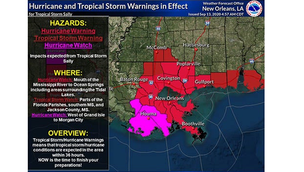
New Orleans and surrounding areas are in the crosshairs of Sally, which was expected to become a hurricane on Monday and reach shore by early Tuesday – bringing hurricane conditions to a region stretching from from Morgan City, Louisiana, to Ocean Springs, Mississippi. Tropical storm conditions were expected in the region by Monday.
Louisiana Gov. John Bel Edwards declared a state of emergency Saturday, and officials in the New Orleans area issued a mandatory evacuation order for areas outside of levee protection.
The tropical storm had maximum sustained winds of 60 mph (95 kph) with higher gusts, forecasters said.
Storm surge from Sally was forecast to reach dangerous levels, due in part to the tide. Up to 11 feet (3.4 meters) of water was predicted from the mouth of the Mississippi River to Ocean Springs, Mississippi, including Lake Borgne.
A slow moving storm, Sally could produce rain totals up to 20 inches (51 centimeters) by the middle of the week, forecasters said. The system was moving west-northwest at 13 mph (20 kph) early Sunday. It was centered 135 miles (220 kilometers) west of St. Petersburg, Florida, and 280 miles (450 kilometers) east-southeast of the mouth of the Mississippi River. Heavy rain was battering the southwest coast of Florida, the Hurricane Center said in its 11 a.m. advisory.
Once a tropical storm, Rene was forecast to become a remnant low Monday. Tropical Depression Twenty was expected to strengthen this week and become a tropical storm by Tuesday, forecasters said.
A low pressure system near the Cabo Verde Islands had a high chance of formation, while a disturbance in the Gulf had a low chance of formation. The Hurricane Center also reported a tropical depression in the central Atlantic that did not appear to threaten land.
More News


-
Polls
 Loading ...
-
-