Natchez in predicted path of possible hurricane; landfall expected late Sunday, early Monday morning
Published 3:44 pm Thursday, August 26, 2021
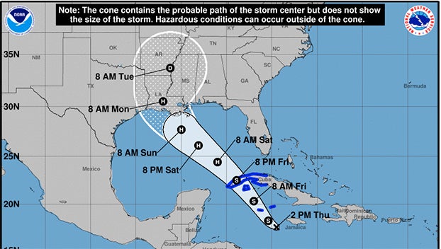
- National Hurricane Center model of the predicted path of Tropical Depression Nine, which forecast to become Hurricane Ida.
|
Getting your Trinity Audio player ready...
|
NATCHEZ — Hurricane forecasters say a tropical depression, known now as Nine, will become a hurricane and take aim at Louisiana and Mississippi as it enters the Gulf of Mexico.
Some models of the storm’s path have it coming inland directly toward Natchez.
The system is expected to enter the Gulf on Friday and strengthen to a category 2 or 3 hurricane. Its likely name will be Ida.
As if his hands weren’t full enough dealing with the resurgence of COVID, Emergency Management Agency Director Robert Bradford and his crew are making plans for the potential of a hurricane following a path to Natchez on Sunday night and Monday morning.
“Right now we have ordered some supplies for the shelter, and sandbags. We are preparing for a possible hurricane arriving late Sunday night or Monday morning,” he said. “We are getting a declaration signed by the Adams County Board of Supervisors right now, which will allow us to mobile when the time comes.”
Bradford will hold a weather briefing at 1 p.m. on Friday at the Adams County Safe Room, near Natchez High School.
“We will be talking about schools and closing offices. We are likely to make all of those decisions at that time,” Bradford said.
At 2:30 p.m. CDT on Thursday, Tropical Depression Nine was located in the western Caribbean, about 200 miles southeast of Grand Cayman.
The National Hurricane Center predicts Nine will be at or near hurricane strength as it approaches the southern Gulf of Mexico late Friday into early Saturday. The warm water of the Gulf is expected to help intensify the hurricane.
Please continue to keep checking at natchezdemocrat.com as more information becomes available.
More News


-
Polls
 Loading ...
-
-