Miss-Lou faces possible severe weather overnight Friday into Saturday
Published 6:42 pm Thursday, December 9, 2021
|
Getting your Trinity Audio player ready...
|
NATCHEZ — Adams County residents should prepare for what could be some rocky weather Friday night and overnight into the afternoon on Saturday.
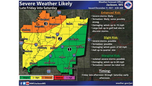
According to a forecast from the National Weather Service in Jackson, Concordia Parish and Adams County are in an area where severe storms capable of producing damaging wind gusts 60 to 70 miles an hour are possible, beginning late Friday night.
The forecast calls for potential tornadoes, some possibly strong, and large hail up to golf ball size through early Saturday afternoon.
“You have a storm system that’s going to move through the region with a cold front associated with,” said Heather Stanley, a meteorologist with the National Weather Service in Jackson.
She said the entire Mississippi River Valley and much of the Delta are in the storm’s path. Storms are possible in our area from 9 p.m. Friday to 3 a.m. on Saturday morning.
Concordia Parish and Adams County are listed as being in an area with a slight risk of severe storms, including possible tornadoes, which could be severe.
“Slight risk means that not everyone will see it. The further south you go, you lose a lot of the instability and ingredients needed to make a storm. Your area just happens to be on that edge. That doesn’t mean you won’t get the storms. Not every storm in that area will hit the severe criteria,” Stanley said.
She said high temperatures on Saturday are expected to be 67 degrees, but overnight lows will be in the upper 30s. Sunday’s high may hit 60, she said.
“It will definitely be cooler behind this system,” Stanley said.
More News


-
Polls
 Loading ...
-
-