BEWARE: Severe weather forecast for Miss-Lou this evening
Published 2:17 pm Wednesday, February 8, 2023
|
Getting your Trinity Audio player ready...
|
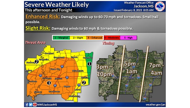
NATCHEZ — The Miss-Lou is in the center of an area the National Weather Service office in Jackson forecasts as having an enhanced risk for severe weather beginning at about 5 p.m. today.
The storm could include damaging winds up to 60-70 miles per hour, tornadoes, and small hail, though meteorologists said hail is a minor concern.
The weather service predicts the storm will be through the Miss-Lou area by 10 p.m. tonight.
The weather service’s forecast for Natchez tonight calls for showers and thunderstorms, mainly before 1 a.m. Some of the storms could produce heavy rainfall. Low-temperature tonight is expected to hit 46 degrees.
Meteorologists forecast windy conditions with a south-southwest wind at 20 to 25 miles per hour, becoming west at 10 to 15 miles per hour after midnight.
The chance of precipitation is 100 percent. New rainfall amounts are expected to be between three-quarters of an inch to one inch.
Thursday’s forecast calls for partly sunny skies through mid-morning, becoming sunny with a high near 65 degrees. Thursday night, mostly clear skies with a low of around 45 degrees.
More News


-
Polls
 Loading ...
-
-