Miss-Lou could end up between two hurricanes early next week; officials ‘on readiness level’
Published 10:07 am Friday, August 21, 2020
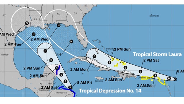
- Weather models from the National Hurricane Center.
|
Getting your Trinity Audio player ready...
|
If the forecasts hold true, Miss-Lou residents could find themselves between two hurricanes early next week.
Adams County Emergency Management officials are keeping their eyes on two developing tropical systems — both headed toward the Gulf of Mexico.
Tropical Storm Laura formed Friday in the eastern Caribbean and forecasters said it poses a potential hurricane threat to Florida and the U.S. Gulf Coast. A second storm, currently called Tropical Depression No. 14 , also might hit the U.S. as a hurricane after running across Mexico’s Yucatan Peninsula.
Adams County Emergency Management Director said the weather system officials are most concerned about is Tropical Storm No. 14, which was nearing the coast of Honduras Friday morning. The U.S. National Hurricane Center said it was expected to veer northwest and cut across the tip of Mexico’s Yucatan Peninsula Sunday, possibly at or near hurricane force.
From there, the long-term forecast track would carry it to the U.S. Gulf Coast, perhaps Texas or Louisiana, by Tuesday or Wednesday — again, possibly, as a hurricane.
Bradford said forecast models would put Natchez and Adams County in the northeast quadrant of the storm, which if it were to become a hurricane would be the most powerful part of the storm.
Bradford said the county is beginning to make preparations.
“We have already started putting plans in place for the shelter as far as COVID-19 protocols are concerned,” Bradford said. “We have put everyone on readiness level.”
County road crews and Natchez Public Works have been notified to start prepping for the storm, Bradford said. Officials plan to meet on Monday for the latest update on the storms and weather preparations, Bradford said.
Bradford said local residents also need to be prepared.
“Everybody needs to have a plan in place in the event of power outages,” Bradford said. “We have to anticipate for weather problems and be ready for it.”
Friday morning, Tropical Storm Laura was centered about 230 miles east-southeast of the northern Leeward Islands, with maximum sustained winds of 45 mph. It was heading west at 21 mph according to the U.S. National Hurricane Center.
Forecasters earlier described it as as a disorganized storm with a very uncertain future. The Hurricane Center said it might degenerate, or it might blow up into a major hurricane that could hit Florida by Monday or Tuesday and then the Gulf Coast.
The current forecast track, also highly uncertain, would carry it just north of Puerto Rico, the Dominican Republic and Cuba, across the Bahamas en route to the U.S.
Robert Bradford,
The one we are looking at tin thenoreast quadrant – that is the most powerful/ Wwaether briefing on Monday.
We have already planned for shelter – set in place as far as COVID-19 shelters. Put everybody on readiness level. If we have.
Most of our road crews and public works, to fgo ahead and start prepping. Monday – Everybody needs to have a plan in the event of power outages. We have anticipate and be ready for it.
The one in Mexio – Tropical Depression – we will be located on ttaht noretheast quadrant 0
More News


SportsPlus
How to Watch the NBA Today, December 13
In one of the eight compelling games on the NBA card today, the Los Angeles Clippers and Denver…
NBA Spread and Total Picks for Today, December 13
The NBA lineup today is not one to miss. The contests include the San Antonio Spurs squaring off…
Best Bets for NCAA Basketball Picks Against the Spread for Friday, December 13
Friday’s college basketball slate has plenty of excitement, including a matchup between the Georgia Southern Eagles and the…
Will Gustav Nyquist Score a Goal Against the Stars on December 12?
When the Nashville Predators play the Dallas Stars on Thursday at 8:00 PM ET, will Gustav Nyquist score…
Saints vs. Commanders: Odds, Moneyline, and Spread – Week 15
The Washington Commanders (8-5) are listed as 7.5-point favorites on Sunday, December 15, 2024 against the New Orleans…
-
Polls
 Loading ...
-
-
Special Sections
