Severe storms expected to roll through Miss-Lou Wednesday afternoon
Published 3:21 pm Tuesday, March 29, 2022
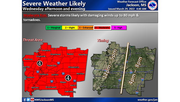
- Courtesy Photo | National Weather Service Jackson Office
|
Getting your Trinity Audio player ready...
|
JACKSON — According to the National Weather Service office in Jackson, a severe storm capable of producing winds with speeds up to 80 miles per hour and tornadoes is forecasted to hit Southwest and Central Mississippi. The storm should hit west Mississippi anywhere from 12 p.m. to 5 p.m. according to the forecast issued at 4:40 a.m. on Tuesday.
In addition to severe storms, Natchez is under a flood warning until April 6 and a wind advisory is in effect Wednesday from 9 a.m. to 7 p.m.
The NWS forecasts 100% rain tomorrow with the amount of precipitation being anywhere from three quarters of an inch to a full inch of rain. As of right now, the Adams County Emergency Management Agency is not recommending any closings due to the timing of the weather system.
Adams County Christian School announced it will have an early dismissal tomorrow. PreKindergarten and Kindergarten will dismiss at 11:00 a.m., 1st through 6th grades dismiss at 11:15 a.m. and 7th through 12th grades dismiss at 11:30 a.m. All after school activities and practices will be closed as well. The breakfast for 8th and 9th graders as well as the PACT will take place as scheduled.
Concordia Parish School District said they are monitoring the weather for Wednesday and will make a decision on schools no later than 8 p.m. Tuesday.
Send photos of storm damage, your name and the location the photos are taken to have them featured in a gallery to hunter.cloud@natchezdemocrat.com.
More News


SportsPlus
Cal Baptist vs. Jackson State Basketball Tickets – Saturday, December 28
The Cal Baptist Lancers (5-5) play the Jackson State Tigers (0-10) at 8:00 PM ET on Saturday, December…
How to Watch SWAC College Basketball Games – Sunday, December 15
SWAC teams will be in action across two games on Sunday’s college basketball schedule. That includes the Arkansas-Pine…
How to Watch UAB vs. Alcorn State Women’s Basketball on TV or Live Stream – December 15
The UAB Blazers (5-3) will host the Alcorn State Braves (1-7) after victories in three home games in…
How to live stream NFL RedZone Week 15 with Fubo
Want to follow the NFL this Sunday? NFL RedZone has you covered providing every touchdown from every contest,…
SWAC Football Scores and Results – Bowl Season 2024
The 2024 college football bowl schedule included one game with a SWAC team. Keep reading to see results…
-
Polls
 Loading ...
-
-
Special Sections
