Wind, storm advisory issued for Miss-Lou; rain expected to begin by noon today
Published 10:39 am Tuesday, January 24, 2023
|
Getting your Trinity Audio player ready...
|
NATCHEZ — The Miss-Lou is included in an area under a wind advisory issued by the National Weather Services, beginning at 3 p.m. today and continuing until 6 a.m. on Wednesday.
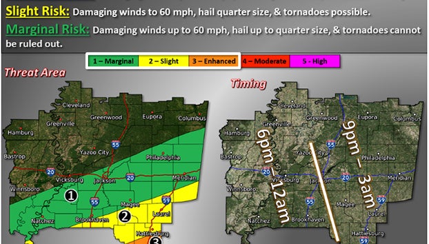
In addition, Catahoula and Concordia parishes in Louisiana and Claiborne, Copiah, Simpson, Jefferson, Adams, Franklin and Lincoln counties in Mississippi area at marginal risk for severe thunderstorms and an elevated risk for flooding today and tonight, according to the forecast issued by the National Weather Service in Jackson.
The forecast call for southeast winds 20 to 30 miles per hour with gusts up to 45 miles per hour for portions of southeast Arkansas, northeast Louisiana and central Mississippi.
According to the forecast, gusty winds could blow around unsecured objects, tree limbs could be blown down and some areas could lose power as a result.
Isolated sever thunderstorms are possible the remainder of today and tonight. Some thunderstorms could produce damaging wind gusts and hail. A tornado cannot be ruled out, according to the weather service.
Showers are expected to begin here at about noon, then a chance of showers and thunderstorms between noon and 2 p.m. Showers and possibly a thunderstorm after 2 p.m. today. Some storms could produce heavy rainfall. High temperature today should be near 64 degrees. Chance of precipitation is 80 percent.
Tonight showers and thunderstorms are expected before 1 a.m., then a slight chance of rain between 1 and 4 a.m. on Wednesday. Low around 41. Chance of precipitation tonight is 100 percent with new rainfall amounts between 1 and 2 inches.
More News


SportsPlus
How to Watch Top 25 College Basketball Games – Saturday, December 14
There are 16 games on the college basketball schedule on Saturday that feature a ranked team. That includes…
Best Bets for NCAA Basketball Picks Against the Spread for Saturday, December 14
Saturday’s college basketball schedule features plenty of excitement, including the matchup between the Gonzaga Bulldogs and the UConn…
How to Watch the NBA Today, December 14
In one of the two compelling matchups on the NBA schedule today, the Houston Rockets and Oklahoma City…
December 14 NHL TV Schedule: TV Channel, Start Times & Live Streaming Options
The NHL lineup today should provide some fireworks. The matchups include the Vegas Golden Knights taking on the…
NBA Spread and Total Picks for Today, December 14
In a Saturday NBA slate that has plenty of thrilling contests, the Atlanta Hawks versus the Milwaukee Bucks…
-
Polls
 Loading ...
-
-
Special Sections
