Forecast calls for severe weather here Tuesday and Wednesday
Published 5:44 pm Monday, April 8, 2024
|
Getting your Trinity Audio player ready...
|
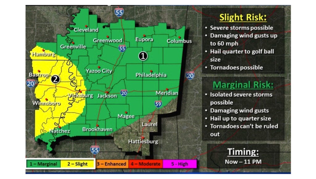
NATCHEZ — The National Weather Service in Natchez is forecasting heavy rain turning to severe thunderstorms on Tuesday into Tuesday night and severe thunderstorms for all day on Wednesday for the Natchez area.
The forecast for tonight — Wednesday — calls for possible thunderstorms, some capable of producing heavy rainfall. Mostly cloudy skies with a low of 65 degrees. Wind gusts could reach 30 miles per hour. Chance of precipitation is 70 percent.
On Tuesday, forecasters call for showers and then thunderstorms beginning around noon. Some storms could be severe and produce heavy rainfall. The high will be near 80.
Meteorologists predict continued showers and thunderstorms on Tuesday night, mainly around 1 a.m. Some storms could be severe. Winds should be southeast around 15 miles per hour, with gusts up to 30 miles per hour. Low Tuesday night will be 65. Chance of rain Tuesday night is 80 percent.
On Wednesday, showers and thunderstorms will continue, some possibly severe. High will be near 77. Chance of rain is 100 percent. New rainfall is expected to be between 2 and 3 inches.
Relief from rain and storms should come on Thursday. The National Weather Service Jackson office forecasts mostly sunny skies on Thursday with a high of 73.
More News


SportsPlus
How to Watch the Braves vs. Phillies Game: Streaming & TV Channel Info for August 31
Orlando Arcia and the Atlanta Braves take the field on Saturday at Citizens Bank Park against Zack Wheeler,…
Braves vs. Phillies: Betting Preview for August 31
When the Atlanta Braves (74-61) play the Philadelphia Phillies (79-56) at Citizens Bank Park on Saturday, August 31…
How to Watch MLB Baseball on Saturday, August 31: TV Channel, Live Streaming, Start Times
The Los Angeles Dodgers and the Arizona Diamondbacks take the field for one of many exciting matchups on…
How to Watch the WNBA Today | August 31
The Connecticut Sun versus the Washington Mystics is the one and only option on today’s WNBA slate. The…
WNBA Betting Picks: Saturday, August 31
Wondering how you should bet on today’s WNBA game? Look no further. Below you’ll find computer predictions on…
-
Polls
 Loading ...
-
-