UPDATE: With worst of weather behind us, flash flood watch remains
Published 12:59 pm Wednesday, April 10, 2024
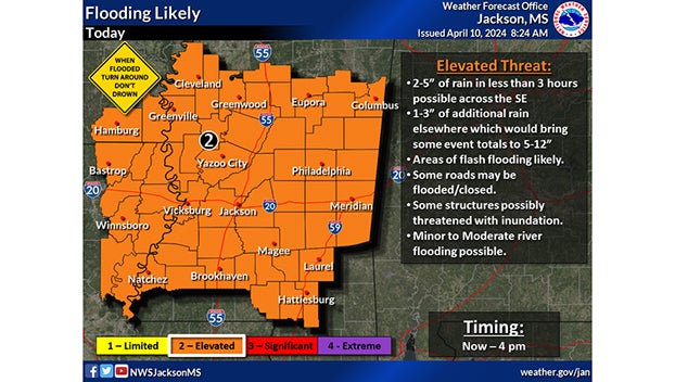
- Map courtesy of the National Weather Service.
|
Getting your Trinity Audio player ready...
|
NATCHEZ — With threats of tornadoes and strong wind subsided, additional heavy rainfall is expected today over the already saturated soil.
Between one and five inches of rainfall is expected throughout the southeast to last through this evening over areas that have already received between four and eight inches of rain bringing event totals between five and 12 inches, with some areas experiencing higher totals.
“This will lead to flash flooding, especially across some western portions of the area where widespread flash flooding is likely,” the National Weather Service states. “Some roads may be flooded or possibly closed, and some structures possibly threatened with inundation. In addition, minor to moderate river flooding will be likely.”
The Miss-Lou region appears to have survived the worst of the storms with fewer than 40 power outages at noon today and no significant damages reported. Some fallen trees were cleared from previously blocked roads.
City and county offices reopened at 11 a.m.
More News


SportsPlus
Braves vs. Mets: Betting Preview for July 27
When the New York Mets (55-48) and Atlanta Braves (54-48) meet at Citi Field on Saturday, July 27,…
How to Watch MLB Baseball on Saturday, July 27: TV Channel, Live Streaming, Start Times
In one of the many exciting matchups on the MLB schedule today, the Cleveland Guardians and the Philadelphia…
How to Watch the Braves vs. Mets Game: Streaming & TV Channel Info for July 27
Travis d’Arnaud and the Atlanta Braves hit the field on Saturday at Citi Field against Tylor Megill, who…
How to Watch MLB Baseball on Friday, July 26: TV Channel, Live Streaming, Start Times
Friday’s MLB schedule includes the Cleveland Guardians taking on the Philadelphia Phillies at Citizens Bank Park. Wager on…
How to Watch the Braves vs. Mets Game: Streaming & TV Channel Info for July 26
Francisco Lindor and the New York Mets meet Travis d’Arnaud and the Atlanta Braves on Friday at 7:10…
-
Polls
 Loading ...
-
-