Natchez, much of Miss-Lou, under tornado watch until 8 p.m. Sunday
Published 12:09 pm Sunday, April 12, 2020
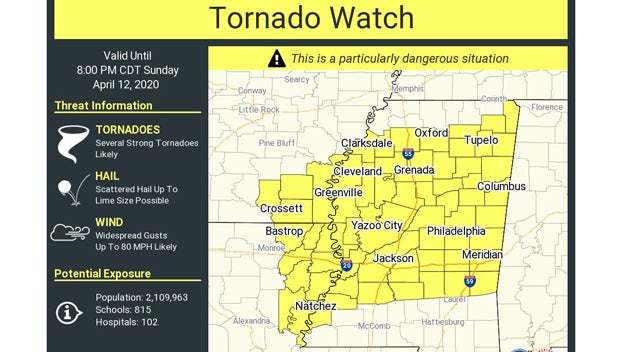
- National Weather Service map shows areas under a tornado watch Sunday until 8 p.m. (NWS)
|
Getting your Trinity Audio player ready...
|
NATCHEZ — The National Weather service issued a tornado watch Sunday morning for much of the Miss-Lou, including Adams County and Concordia Parish, Louisiana, and other parts of Southwest Mississippi until 8 p.m. Sunday.
A tornado watch means conditions are right to possibly produce tornadic activity.
Adams County Emergency Management Director Robert Bradford Sr. said Friday that the Adams County Safe Room off of Liberty Road would be open for people seeking shelter in Adams County when a tornado watch is issued.
“The Safe Room will be open, but we will have safe guards in place for the COVID-19,” Bradford said. “Everyone needs to be prepared for power outages, down trees across roads or street. And if any residents have any damages to their property they can call the Emergency Operation Center at 601-445-3525 or go online to adamscountyms.net and report it on Crisis Track.”
People sheltering at the Safe Room are asked to bring their own masks and gloves if they have them and if not, protective wear will be provided to them at the Safe Room.
Bradford said hand sanitizer will be available and people will be required to keep a safe distance between themselves. Pets are welcome, but must have a kennel and one pet per family is allowed. People are asked to bring their own blankets and medications.
Bradford said people planning to stay in the shelter can call ahead for more information at 601-445-3525.
Van Byrd, a meteorologist with the National Weather Service Office in Jackson said Friday that the frontal system was forecast to move through the state Sunday morning and last into the early evening with rain, the possibility of tornadoes and golf-ball-size hail.
Byrd said outbreaks of tornadoes are expected in the state with some possibly being long-track tornadoes that could travel on the ground for a long distance. Besides the hail, damaging winds with speeds up to 70 mph are also expected.
Cooler weather will follow the system, with highs in the 60s and lows possibly falling into the 40s Wednesday and Thursday with temperatures warming up after Thursday.
More News


-
Polls
 Loading ...
-
-