Tropical Storm Lee begins pelting Gulf Coast
Published 11:42 am Saturday, September 3, 2011
NEW ORLEANS (AP) — Heavy rains from Tropical Storm Lee were falling in southern Louisiana and pelting the Gulf Coast on Saturday as the storm’s center trudged slowly toward land, where businesses were already beginning to suffer on what would normally be a bustling holiday weekend. The storm was expected to drop 10 to 15 inches of rain across southern Louisiana.
Tropical storm warning flags were flying from Alabama to Texas and flash flood warnings extended along the Alabama coast into the Florida Panhandle. The storm’s slow forward movement means that its rain clouds should have more time to disgorge themselves on any cities in their path.
The National Hurricane Center said Lee’s center was about 45 miles (72 km) southwest of Morgan City, moving north at 6 mph (9 kph) with maximum sustained winds of 60 mph (97 kph).
It was expected to cross the Louisiana coast Saturday and meander through the state’s southern parishes through Sunday.
They expected the storm to fluctuate in strength through the day, though it was not expected to reach hurricane strength. Its surge was pegged at 4 feet high above normal sea level in Shell Beach, and 2 feet as far east as Pascagoula, Miss.
Lee has confounded forecasters since it began developing at midweek and pulled another surprise overnight Friday by coming out of a virtual stall and moving north toward the central Louisiana coast.
In New Orleans, sporadic downpours caused some street flooding in low-lying areas early Saturday, but pumps were sucking up the water and sending it into Lake Pontchartrain. Lee’s storm surge so far had not penetrated levees along the coast, said National Weather Service forecaster Robert Ricks in Slidell, La.
Ricks said Lee so far has dropped as much as 7 inches of rain in southeast Louisiana and would continue to be a major rainmaker as it moved inland Saturday. The storm was expected to lift erratically to the north through Sunday before being picked up by a cold front and zipped off to the northeast.
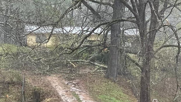
Tornado warnings were issued overnight in Louisiana and south Mississippi but Ricks said there were no confirmed touchdowns. So far, damage appeared confined to downed power lines and trees.
But he cautioned Lee’s impact would continue to be felt.
“In a storm like this, tornadoes can flash up for a few seconds or a minute and be gone. We expect more sightings on Saturday,” Ricks said.
Ricks said Lee probably had reached its maximum intensity and was unlikely to become a hurricane as it pushes ashore.
Earlier it appeared Lee was on track to pass directly through the New Orleans area, but its overnight move caused forecasters to shift its projected track farther to the west. Heavy rain could pelt the Baton Rouge and New Orleans area for the next 36 hours.
Entergy, a major utility in the region, reported more than 35,000 customers without power, mostly in the New Orleans area and along the coast. There were scattered outages well inland into central Louisiana and Mississippi.
Lee was the first named storm to make landfall in Louisiana since Hurricane Gustav, which struck on Labor Day in 2008.
Gustav provided a major test of rebuilt levee protection in New Orleans, where billions of federal dollars were spent after levees failed during Hurricane Katrina and flooded an estimated 80 percent of the city.
On Saturday, levees were holding, though sandbagging had been done in some places as a precaution.
Gusty winds whipped through the downtown area, but bridges, including the 24-mile-long Lake Pontchartrain Causeway, remained open to traffic.
Though local officials urged residents to prepare for the worst., Lee appeared to be a holiday weekend annoyance for many people. Some didn’t expect the tropical storm to live up to the legacy of killer hurricanes like Betsy, Camille and Katrina.
“It’s a lot of rain. It’s nothing, nothing to Katrina,” said Malcolm James, 59, a federal investigator in New Orleans who lost his home after levees broke during Katrina in August 2005 and had to be airlifted by helicopter.
The storm was washing out Labor Day weekend festivities, with cancelations of parades and other events in Orange Beach and Gulf Shores, Ala. In Louisiana, programming was canceled at state parks and historic sites in the southern part of the state.
Merchants worried the storm would dampen the Southern Decadence festival, an annual gay lifestyle fixture that rings cash registers on Labor Day weekend in the French Quarter. Ann Sonnier, shift manager of Jester’s bar, said receipts were disappointing so far.
“People are probably scared to death to come here after Katrina,” she said.
Southern Decadence organizers said events would go on, though many would be moved indoors.
Some tourists were caught off guard by Lee, but didn’t let it dampen their spirits.
“I didn’t even know about it,” said Kyla Holley of Madison, Wis., who along with husband Rob was in town for the Labor Day weekend holiday. “But it wouldn’t have stopped us from coming.”
Lee comes less than a week after Hurricane Irene killed more than 40 people from North Carolina to Maine and knocked out power to millions. It was too soon to tell if Hurricane Katia, out in the Atlantic, could endanger the U.S.
The storm’s biggest impact, so far, has been in the Gulf of Mexico oil fields. About half the Gulf’s normal daily oil production has been cut as rigs were evacuated, though oil prices were down sharply Friday on sour economic news.
Federal authorities said 169 of the 617 staffed production platforms have been evacuated, along with 16 of the 62 drilling rigs. That’s reduced daily production by about 666,000 barrels of oil and 1.7 billion cubic feet of gas.
Governors in Louisiana and Mississippi, as well as the mayor of New Orleans, declared states of emergency. Officials in several coastal Louisiana and Mississippi communities called for voluntary evacuations.
The Army Corps of Engineers closed some floodgates along canals but had not moved to shut a massive flood structure on the Mississippi River-Gulf Outlet shipping channel.
The MRGO was a major conduit for Katrina’s storm surge, which overwhelmed levees and flooded St. Bernard and the city’s Lower 9th Ward.
Lee’s storm surge, projected around 4 to 5 feet, is far short of the 20-feet-plus driven by Katrina. Billions of federal dollars have been spent on new levees and other flood protection. City officials said they were prepared to deal with street flooding.
The water-logged Lee was tantalizingly close to Texas but hopes dimmed for relief from the state’s worst drought since the 1950s as the storm’s forecast track shifted east. Forecasters said it could bring drenching rains to Mississippi and Alabama early next week.
On the Mississippi coast, tourism officials said there was no spike in cancellations for the holiday weekend at hotels and casinos.
On Grand Isle, Louisiana’s only inhabited barrier island, people kept an eye on the storm that was already bringing rain there. It’s not as frightening as having a Category 2 or 3 hurricane bearing down, said June Brignac, owner of the Wateredge Beach Resort.
“But we’re still concerned with all the rain that’s coming in, causing possible flooding of the highway going out. If we don’t leave, we may be trapped here until it’s completely past,” she said.
The rain, however, had a silver lining. In New Orleans, it was helping to tamp down a stubborn marsh fire that for several days has sent pungent smoke wafting across the area.
Southern Louisiana needs rain — just not that much, that fast.
“Sometimes you get what you ask for,” New Orleans Mayor Mitch Landrieu said. “Unfortunately it looks like we’re going to get more than we needed.”


